By Nicoletta Metri
In April 2019, a magnitude 6.1 earthquake shook the island of Luzon in the Philippines. The earthquake left more than 200 people injured and 18 dead – including five in a collapsed supermarket. The next day, a magnitude 6.4 earthquake shook the islands of Visayas, approximately 600 kilometers away. It was the 18th major earthquake to strike the country since 2010.
The Philippines is located along the Ring of Fire, a large horsehoe-shaped area in the Pacific Ocean known for its seismic activity. The country’s telecommunications networks can be spotty even during the best of times, but in the wake of these kinds of natural disasters, limited communications and difficult terrain can make the deployment of resources especially difficult. Unmanned Aerial Vehicles (UAVs) – more commonly known as drones – can be a powerful tool to speed up the post-disaster assessment process. They can help monitor road conditions, assist rescuers in finding stranded people, and act as alternative transportion for different types of payloads – such as a sensor network system for gathering information.
The Internet Society Philippines Chapter explored the use of drones during post-disaster operations, including the coordination of search, rescue, and retrieval. Their project, “Unmanned Aerial Vehicles For Post-Disaster Resilient Communications,” supported by the Internet Society Foundation and its Beyond the Net Grant Programme, developed new capabilities and techniques using drones for environmental monitoring and disaster response.

The project leader Benjz Gerard Sevilla describes their objective: “We aimed to create an architecture capable of delivering high-quality content over wireless local area network and the ability to optimally use the limited available bandwidth. Our research included the design and development of applications, web interfaces and hardware infrastructure that would set up this type of architecture for use in remote locations. This would provide users with an Internet experience that is equal to that of developed countries.” ”
Background
Aerial imaging mission was launched first to gather the datasets necessary for feature tracking, extraction, and image processing. In partnership with SkyEye Analytics and International Organization for Migration, the project participated in high-resolution drone imaging of communities in Batasan, Pateros, and Navotas, where identifying safe routes and evacuation checkpoints were needed.

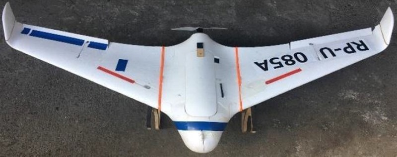
Benjz explains: “We developed our custom UAV using an X-8 flying wing EPO foam airframe, which is a divergence from our original design using the Super SkySurfer airframe. The flying wing allows us to carry more payload mass without heavily modifying the fuselage while still maintaining 45 minutes to 80 minutes of flight time.”
Disaster Simulation: Distress Signals, Aerial Images, and Infrastructure
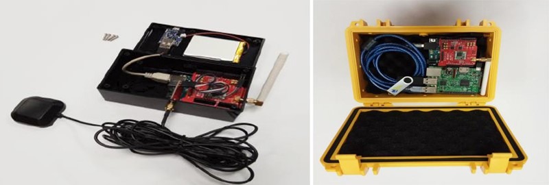
Three types of simulation missions were deployed by the team using low-cost, mobile computers. The first collected distress long-range radio signals from “survivors” that were equipped with kits developed by the project team. These kits are compatible with smartphones and continuously transmit GPS coordinates of survivors via 433MHz long range (LoRa) modules. The modules transmit messages of up to 251 characters containing the location, name, and other identification info. The team also designed and developed kits that seamlessly gather, sync, and store beacon data and other critical data in the field.

The second had a specialized payload consisting of cameras and high-bandwidth communications channels. The drones took aerial images of the survivors and roads, establishing an on-demand communications link between the survivor and the command center. The third was deployed upon the passability of roads and provided survivors a more permanent communications link as well as power and other resources.
Next Steps
The initiative successfully demonstrated innovative systems ready to be deployed in real-world disaster scenarios. The results have been shared with partners and to the scientific community through an international symposium, seven conference papers and presentations, and five “Dissemination and Community Engagement” workshops.
Moreover, this project contributed to a new communications standard. “Specification of Information and Communication System Using Vehicle during Disaster” was developed in partnership with the Ateneo Innovation Center and the Department of Information and Communications Technology (DICT) in Manila.

While anyone can say that disasters are commonplace, the team shares the “zero casualty” goal of the Philippines. They hope the technology applications they’re developing will benefit their communities and help other Internet Society Chapters address the pressing issue of disaster management across the world.
Read more:
A drone project to change humanitarian disaster response in the Philippines.
